- Home
- Proposals
- The Arguments
- About Us
- News
- BBC bias on climate change
- Latest News
- Climate change balance lost by BBC
- Energy Prices-The Times
- Turbines trash landscape benefit billionaires
- Global Warming Panic Over!
- Mini-Nukes the future
- The dirty secret of Britain's power madness
- Extreme weather the new Global Warming
- Tax Payers Alliance Energy view
- Britain can't afford wind power
- Fracking = prosperity?
- Its time to drill- Times leader
- Thoughtful article on Fracking
- Wind double subsidised
- Deluded energy policy
- The EU U-turn over energy
- Windfarm Wars Company in Churchover
- New noise guidance increases risk of harm
- Peter Lilley MP, Delingpole's new hero
- Shale Gas update 2013
- Maggie U-turned on Global Warming
- Devastatingly sad news
- 'smart' energy technology
- Engineers surveyed 2011
- Lord Turnbull speaks out
- Miracle shale gas
- Planning application refused!
- Warwickshire heritage beauty spot protected!
- Press
- Articles
- Letters
- How To Help
- Donations
- Letters of Objection
- New Churchover PC Objection
- New Historic England Objection
- Churchover Resident Objection
- CPRE Objection
- English Heritage Objection
- Objection by expert R&F historian
- Leicestershire County Council objection
- Warwicks CC Ecology objection
- Harborough District Objection
- Churchover PC Objection
- Bitteswell PC Objection
- Pailton PC objection
- Some other Objections sent
- Rugby BC Planning Committee
- Contact Us
Objection by expert R&F historian
Objection to the disastrous destructive intrusion of wind turbines (R12/2009) into the Churchover ridge and furrow landscape by the expert historian David Hall
Ridge and furrow was formed as a result of the ploughing methods used by medieval and more recent farmers who operated an open-field strip method of farming. Each ridge represents an ancient strip. After enclosure, hedges were set and farms based on a system of intermixed strips were abandoned for equivalent areas lying in ring-fenced ‘modern’ farms. In the case of Churchover, this occurred in 1755 (Tate and Turner 1978, 256). Thereafter some fields were left as permanent pasture which preserved the strips as ridges. A description of open-field farming and its historical context has been given (Hall 1982), and national context can be studied in a forthcoming book (Hall, June 2014).
Ridge and furrow forms an attractive part of the landscape in some areas. Although once common in the Midlands, especially on the Warwickshire-Northamptonshire border, it is now a fast diminishing resource, as more farms convert to an arable economy because of low dairy returns. In 2001 English Heritage made an assessment of Midland ridge and furrow, recommending some 40 important national sites that should be preserved as far as possible (Hall 2001). Churchover was not part of that list, but never-the-less should be preserved as far as possible, especially in view of its relationship to Cestersover. The 2001 English Heritage analysis identified samples of ridge and furrow adjacent to medieval settlement earthworks as of importance.
Significant areas of ridge and furrow are now getting very scarce and one of very exceptional quality such as occurs at this site is very important. The rapid disappearance of the monument form has been mapped for adjacent Northamptonshire in the accompanying illustrations (taken from Hall 2013, figures 32 and 33). It is evident that if no action is taken very soon to preserve ridge and furrow there will be none left, and it will not be possible to study or appreciate the mode of agriculture used in England for nearly a millennium.
Within the area of the proposed windfarm, the surviving ridge and furrow forms a block north of Churchover next to meadowland by the River Swift, and links directly with the village to include river loop to the north-west and shrunken village earthworks on the west. Across the Swift, the deserted village of Cestersover has well-preserved earthworks and more ridge and furrow. There are interesting variations in the profile of the ridge and furrow that will reflect its age and subsequent land-use, and enhances the historical potential and interest.
The whole block represents a well preserved piece of medieval landscape worthy of preservation. It places Churchover and Cestersover villages in their agricultural context, both archaeologically and as a visual asset to Churchover and neighbouring villages, as well as Rubgy Borough generally.
Comments on the proposed site.
The proposed generators represent a disastrous destructive intrusion into this landscape. As well as the permanent adverse visual effect, there will be extensive damage caused by the site construction with its linking trackways.
This will affect the ridge and furrow itself, as well as any underlying archaeological remains. In the event of the site going ahead, then any preconstruction archaeological work should include recording buried soil profiles and older furrows that may lie under the ridges, as well as identifying other structures such as Roman remains.
Bibliography
Hall, D., 1982. Medieval Fields, Shire Publications (reprinted 2010).
Hall, D. 2001. Turning the Plough (English Heritage and Northants County Council).
Hall, D. 2013, in Partida, T., Hall D. & Foard, G., Northamptonshire, An Atlas of the medieval and early-modern landscape; (Oxford: Oxbow).
Hall, D. 2014, The Open Fields of England, (Oxford University Press).
Tate, W.E. and Turner, M. E. 1978. A Domesday of English enclosure acts and awards.
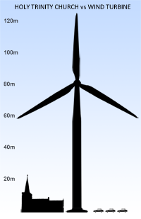
Holy Trinity Church, mentioned in the Domesday Book of 1086, has dominated the Swift Valley for 1,000 years. Above is an accurate representation of the relative sizes of the church spire and the proposed monstrous turbines that will vandalise the heritage of the area.
Donate Now!
Please donate now to help pay for a lawyer to represent the community at the Called-In appeal hearing.