- Home
- Proposals
- The Arguments
- About Us
- News
- BBC bias on climate change
- Latest News
- Climate change balance lost by BBC
- Energy Prices-The Times
- Turbines trash landscape benefit billionaires
- Global Warming Panic Over!
- Mini-Nukes the future
- The dirty secret of Britain's power madness
- Extreme weather the new Global Warming
- Tax Payers Alliance Energy view
- Britain can't afford wind power
- Fracking = prosperity?
- Its time to drill- Times leader
- Thoughtful article on Fracking
- Wind double subsidised
- Deluded energy policy
- The EU U-turn over energy
- Windfarm Wars Company in Churchover
- New noise guidance increases risk of harm
- Peter Lilley MP, Delingpole's new hero
- Shale Gas update 2013
- Maggie U-turned on Global Warming
- Devastatingly sad news
- 'smart' energy technology
- Engineers surveyed 2011
- Lord Turnbull speaks out
- Miracle shale gas
- Planning application refused!
- Warwickshire heritage beauty spot protected!
- Press
- Articles
- Letters
- How To Help
- Donations
- Letters of Objection
- New Churchover PC Objection
- New Historic England Objection
- Churchover Resident Objection
- CPRE Objection
- English Heritage Objection
- Objection by expert R&F historian
- Leicestershire County Council objection
- Warwicks CC Ecology objection
- Harborough District Objection
- Churchover PC Objection
- Bitteswell PC Objection
- Pailton PC objection
- Some other Objections sent
- Rugby BC Planning Committee
- Contact Us
An analysis of Landscape vandalism
Below is what we believe to be a dispassionate analysis of the issues around the impact of wind turbines on the Swift Valley / Churchover/ Cotesbach/ Pailton landscape.
The summary of our case :-
1) We explain the theoretical technical methods used in the planning permission process that attempts to translate a subjective view into an objective analysis.
what Landscape & Visual Impact Analysis (LVIA) is about READ MORE…
2) Rugby Borough’s present bias towards a restricted and pro developer method of assessment.
3) How people will see in reality the wind turbine landscape and Churchover.
The trivialisation of the scale of the development. Ignoring effect of turbine motion. Churchover will experience the worst combination of scale and distance.
4) Should the history and heritage of Churchover and the Swift Valley be ignored?
The present unity of the whole - farmland, river and settlement, - is remarkably pure. The relationship there has been for 1,000 years between the church, the village and the land will be destroyed.
5) The likely scenario should our concerns be ignored.
- A brownfield site from Rugby to Lutterworth ripe for opportunist housing and warehouse development that creates an urban sprawl and goes against the agreed Rugby structure plan.
1) Two methods of landscape visual assessment LIA and VIA
2) Rugby Borough’s landscape assessment initiative
Rugby Borough Council has (November 2010) commissioned a firm of consultants (The White Partnership from Cardiff) to undertake a “Landscape Capacity” study of the Borough and this is due to be completed and issued about February/March 2011. The study is effectively an LIA intended to advise which areas of the Borough have capacity to absorb windfarms of various types and scales without giving rise to unacceptable changes in landscape character.
It is our understanding that the study will not be a VIA. So, it will be perfectly possible for it to conclude that, in character terms, particular areas of the Borough have the capacity to absorb a given windfarm, while paying no heed to serious visual impacts upon people.
Unfortunately, this is all of a piece with the Borough’s response to landscape issues raised by other developments, which seems to be dominated by LIA assessments and not the often more meaningful VIA assessments. The Rugby Gateway proposal (1300 houses plus a business park by M6 junction 1) is one such current development where assessment ignores or downplays the VIA element.
Moreover, although the Borough is “committed to effective communication” about their landscape capacity study, they seem not to be quite so committed to “effective consultation”. Although one or more presentations are envisaged before publication, at present it is unclear that any worthwhile opportunity for consultation will be provided. It is reasonable to fear that we shall be presented with a fait accompli, identifying areas of rural landscapes in the Borough which might have the capacity to absorb windfarms, but without also considering impacts upon people. ASWAR members have put these points to the Borough, but we are not optimistic about a favourable response.
3) The Churchover Windfarm and the landscape
Thus far, the Scottish developers have produced solely LIA images, which some people will have seen at the October public exhibition in Churchover. That exhibition showed how misleading such images can be.
Everyone acknowledges that to translate how people view landscapes when standing in the countryside, into a picture on a piece of A3 paper or a display board, is not easy. There are many techniques available, all having some advantages and disadvantages, and none is perfect. Some techniques are more suitable for some types of development than others: for example, visual assessment for a new housing estate and a windfarm might require very different approaches.
To present their windfarm proposals developers usually use the LIA approach. It is based upon very wide-angle panoramic images, with a 180o field of view (sometimes even more, 270o or 360o) upon which proprietary computer programmes drop pictures of wind turbines, hopefully in the right locations and to the right scales. In effect, they try to represent what you would see if, standing in the countryside and looking at a windfarm, you were to turn your head, and your body, through 180o or more. Indeed, we look at some views in exactly that way – think of climbing to the top of a mountain and looking around – so this LIA approach is not factually wrong. Below is an example that the Developer has created from a wide view that they proudly presented at their propaganda exhibition in October. It may be factual but does it give the accurate and correct presentation ?
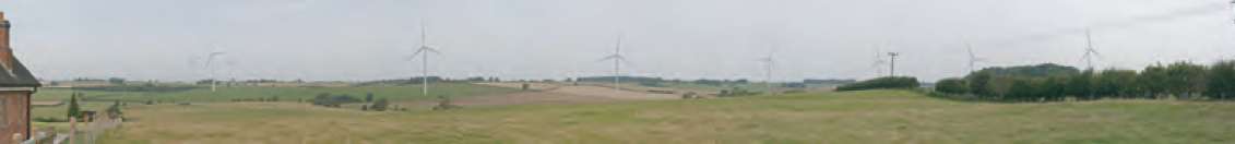
It is far from the whole story. We also view landscapes much more narrowly – from our gardens, windows, through windscreens while driving, filtered through trees while walking, through spectacles, and so on – so that whereas landscapes can be viewed at 180, 270 or even 360o arcs, we can also view them without turning our heads, at arcs of only about 30-40o. When driving at speed, our arc of view is even narrower – 10o or less.
So, putting this into the Churchover context, standing at leisure at the top of the hill on the road to the ford and looking back (north) over the whole village and Swift Valley, we might see roughly the LIA panorama visual of all 9 proposed turbines. Driving northwards around the same corner, we might register much less of a panorama, perhaps only 2-3 turbines. Sitting in our back gardens, we might see only 1 turbine or even only a part of one. The visual impact of each would be different.
Unfortunately, what the LIA panorama views tend to do is to trivialise the scale of the development by emphasising the wider landscape, whereas the VIA narrower view tends to emphasise the development rather than the landscape. Each approach tends towards opposite extremes, but each is necessary as part of a full assessment.
Below is a draft example we have made up as accurately as possible using known fixed heights in the background to give correct scale for a narrower view of just 5 turbines.
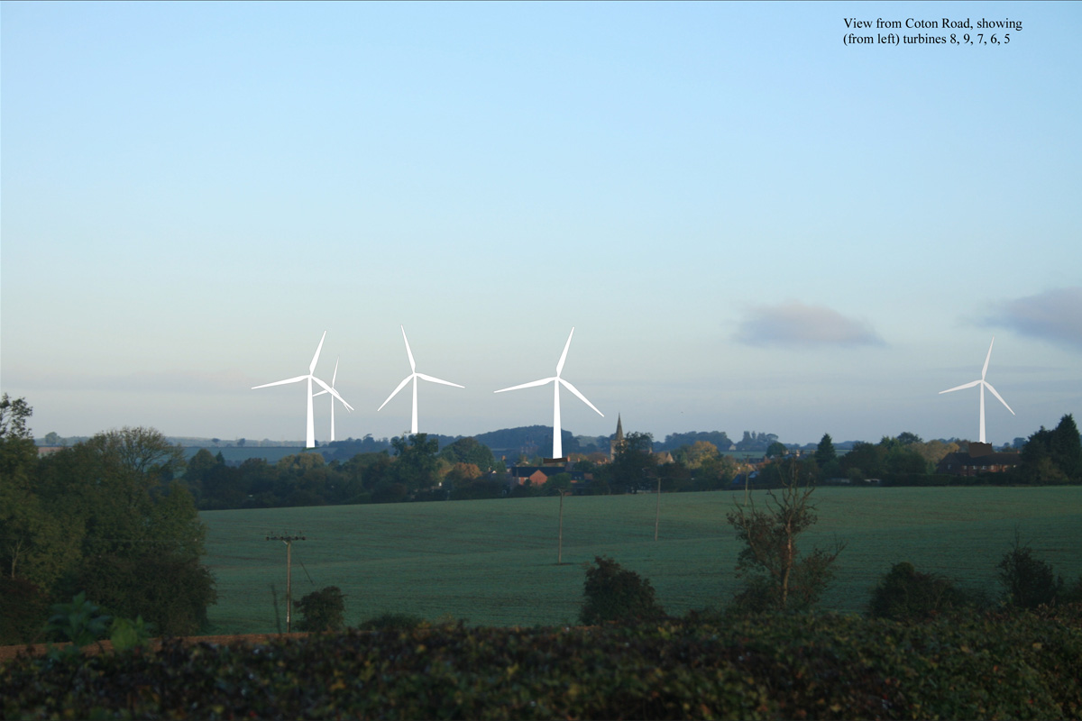
Next, is a view of three turbines behind what some of the children of the village call 'Magic Wood' (Ryehill Spinney). The heights of the turbines are proportionately copied from the developers wide angle montage, to a view that would normally be seen from the field footpath. Perhaps the children will rename it 'scary wood'!

The developer's approach also assumes that the development does nothing that attracts the eye. One thing wind turbines do (not always but sometimes!) is revolve and motion attracts the eye to them. The eye tends to be drawn towards the turbine rather than the landscape.
You can test this for yourself. The new multi storey car park at Rugby Station has two small wind turbines on the roof. You will find yourself noticing these much more readily when they revolve than when they are stationary. Think of the Rugby Cement pre-heater tower: you notice that far more easily when there is a plume of visible gas than when the works is stopped and no gas emerges. Think of how flags appear, in still air and in the wind.
So, visual analysis of stationary objects only goes so far. Windfarms are also known for their “shadow flicker” effect when turning in certain light conditions. This is a type of effect that aggravates the eye catching power inherent in revolving.
Two other important variables, especially in the Churchover context, are scale and distance. It is obvious that, other things being equal, the visual impact of a given wind turbine will usually be greater the nearer it is, and smaller the further it is, in relation to the viewer. Second, at a fixed distance from a viewer, the larger the turbine the greater impact it will have.
Churchover will experience the worst combination:
- very large turbines (126m high, among the largest sizes currently proposed on shore)
- very close to the village (the nearest is 700-800m from the village and only 500m from Leatherlands Barn, under convertion to residential and 650-700 from Briar Cottage on Montilo Rd.
- all crammed within a short distance contained within the Swift Valley – the furthest turbine away from the village is only 1600m.
When many authorities advise minimum distances of 1500-2000m from settlements, to have this proposal all within 1600m is likely to create a major adverse visual impact.
What does Scottish Natural Heritage, a strong supporter of renewable energy and the main current source of UK guidance on landscape impacts, say?
- “our support for renewables has to be balanced with …… commitments and aspirations to conserve and enhance the natural heritage, including the quality and diversity of … landscapes.”
- “Wind turbines are generally large structures with the potential to have significant landscape and visual impacts.”
- “The development of windfarms, including associated infrastructure such as tracks, power lines and ancillary buildings, has already had a major impact on many of Scotland’s landscapes….”
- “large wind turbines may appear out of scale and visually dominant in lowland, settled or smaller-scale landscapes” (such as the Swift Valley and virtually the whole Rugby area)
Even bodies which endorse renewable energy admit it can have drawbacks!
4) Landscapes and cultural impacts
Landscapes are not just products of geology, geography, climate and ecology; they are also the result (in the UK at least) of centuries of human endeavour. Churchover, like hundreds of other rural villages in Warwickshire, maintains a close association between the village and the land that has supported it for two thousand years. Only in the last fifty years have active farm buildings moved out of the village and even so the land today, including the whole of the windfarm site, remains in the same mixed arable/cattle/sheep grazing pattern that it has enjoyed for millennia. Nor has the landscape been stripped of hedgerows. The traditional field patterns, and names, remain.
Below Cestersover Farm, in the “core” of the proposed windfarm complex, lies the deserted Mediaeval village of Cestersover, aerial photographs of which are used to illustrate Beresford’s classic archaeological text.
To this settled and undamaged pattern of landscape history must be added the interaction between the landscape and its village, for Churchover is a Conservation Area (and contains many Listed Buildings), designations which confirm that in many important ways it retains its historic aspect.
The unity of the whole – farmland, river and settlement – is remarkably pure, especially so close to Rugby.
One of the iconic Midland's views of a tall 9th Century steepled Church on a hill, that can be seen from all around 'over the fields' , dominating a river valley and conservation village, surely has to be protected.
Landscape conclusions
As far as we can tell from present knowledge:
- The Borough Council is undertaking a landscape capacity study that seems likely to concentrate upon LIA and not VIA and will therefore underplay or ignore vital aspects of landscape assessment
- The developers have thus far concentrated upon panoramic LIA visual representations of the entire proposed windfarm. Although they are understood to be in discussion with the Borough about selecting additional viewpoints for visual assessment, we seem not to be allowed to be involved in that process and have no guarantee that it will include narrower focus VIA assessment.
- If you doubt the importance of VIA work, our own (draft) photomontage gives a fair illustration of the potential visual impact on the village from just 5 of the turbines.
- The proposal of 9 turbines, 126m tall and all located between 700m and 1600m from the village, and 500m from isolated property, is probably an unprecedented concentration of development and scale in such a very small area.
- By industrialising the Swift ‘gap’ between Rugby/M6 and Magna Park, the windfarm will not only destroy the landscape quality of Churchover and the Swift Valley. It will also risk reducing and perhaps eliminating the current separateness of Rugby from Lutterworth.
- The windfarm will (allegedly) be removed after 25 years. However, remember that the “Mast Site”, “Rugby Radio Station” or “British Telecom Site” on the A5 near Clifton – which contained large numbers of tall radio masts now mostly demolished and looks like green fields again – is still deemed to be “previously developed” or “brownfield” land and is now allocated for over 6000 houses and millions of square feet of warehousing. Exactly the same reasoning could hold for Churchover as a windfarm approached the end of its life.
- The proposed windfarm is not, therefore a temporary intrusion which leaves the landscape largely undamaged during its life and is restored after 25 years (the enormous concrete foundations will always remain). It will be a major, over-bearing, looming, out of scale, industrial intrusion destroying for 25 years the historic landscape, conservation area and village and giving rise to a serious risk of permanent and 100% landscape destruction thereafter as brownfield land for major built development.
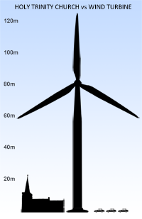
Holy Trinity Church, mentioned in the Domesday Book of 1086, has dominated the Swift Valley for 1,000 years. Above is an accurate representation of the relative sizes of the church spire and the proposed monstrous turbines that will vandalise the heritage of the area.
Donate Now!
Please donate now to help pay for a lawyer to represent the community at the Called-In appeal hearing.